 |
Abstracts of Conference Papers
Coastal Photographic Survey
Bob Winters
Education Programs Manager
Gould League of Victoria
|
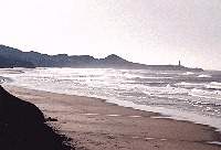
The purpose of developing guidelines to photograph the coast is to enable community groups to make a valuable contribution to the monitoring of environmental change along our coast. The photographic record of some key aspects of our environment may have a major impact on how we manage our coastal environment in future years. In the next few years there should be software that will have the capacity to analyse the differences between photographs taken at different times. |
 |
It has taken considerable scientific endeavour, resources and time to identify the health of Melbourne’s Port Phillip Bay. In monitoring the health of our coastal environment, many if not most methods are beyond the limited resources of community groups and individuals. However, there are other extremely valuable possibilities. One of these, is to create an ongoing photographic record of certain elements of the coastal environment.
When explaining natural environmental change, many educators choose to focus on the coast. With the action of tides and the physical extremes of weather and pounding waves, the interface between sea and land rarely remains constant. Coupled with the human impact factor, our coast is vulnerable to degradation. An important aspect in the challenge to protect our environment is, not only to monitor change, but also to develop early warning devices that quickly identify accelerating environmental degradation.
If we examined what people thought the key environmental issues were 20 years ago and compared those with our concerns today, we would probably find some outstanding omissions. For example, greenhouse issues would not have been included in 1977. We may well find in 20 years time there will be a number of major environmental problems that we today failed to foresee.
Scientists are able to monitor most aspects of our environment, however this work will almost always be limited by the lack of resources. How can community groups try to fill in some of the gaps? What can community groups do independently of the laborious and often costly scientific methods employed in monitoring the coastal environment?
How can community groups contribute to the protection of the environment, when we do not comprehend the full extent of future threats and the real possibility of unknown environmental hazards? What can these groups do to develop an early warning system? How do community groups develop a credible data bank that will be accepted by the decision-makers?
The old saying "photographs don’t lie" may provide the insight for community groups to develop a meaningful and credible database of environmental change. In our visual world we recognise, "a photo is worth a thousand words." Photographic evidence may be more helpful for understanding the issues than struggling with scientific technology and statistics.
Above-water photography is a recording method available to all community groups. Over the past few years, many new methods for recording and storing images have become cheaply available to the public. What to photograph, how to do it and with what equipment and how to store the information are the important elements to a successful photo survey program.
This document is only the start of a longer process. As people start photographing, they will discover additional key environmental indicators worthy of recording. New technologies are continually being developed, thus creating new windows of opportunity. The entire process should be seen as one that can evolve and be adapted to local needs.
Major purposes for developing a coastal photo survey
What are the reasons for starting a photo survey? The choice of photographic subjects depends on the answer to this question. Some of the suggested reasons are:
- Keeping a record to identify environmental change over a long period of time.
- Having an early warning system and providing a valuable database on the local environment.
- To record the valuable work done by community groups in restoring the coastal environment.
- To monitor specific impacts on the environment including recreation, development, illegal removal of trees etc.
Frequency of photographs
How often will photographs be taken? It could be:
- A single reference set that may be very useful ten to twenty years later.
- Photograph every year at about the same time with similar weather pattern and tide.
- Photograph every quarter or two months to add to the knowledge of seasonal change.
- Photographed even more frequently to provide variations in weather and seasons.
Photographing what?
What will be photographed will depend largely on which monitoring opportunities are available. This could include:
- Coastal vegetation
- Tidal marine life living on various surfaces
- Development
- Structures
- Beach sand and erosion
- Recreation and commercial activities along the coast
To ensure that the photographs are a valuable future record, note the exact location and orientation of each photo.
Equipment
These are some of the most important considerations:
- The kind of equipment to be used
- The focal length of the lens to be used
- The type of film
- Being able to guarantee that a similar setup of equipment will always be available.
- It is essential to have a thoughtful photographic and work procedure that keeps equipment free of salt, water, sand, dust and harmful heat through long exposure in direct sunlight.
Filing
All the work will be meaningless unless the photographs are filed along with all the relevant and necessary information for future workers. Record with the photos:
- Time and date and local conditions
- Exact location and orientation of each photo
- A code that links photos to each other
- Any special notes about conditions etc
- A storage location, which is known by the local community group and Coast Action or any future body that may replace it.
The challenge: Monitoring a changing environment.
There are many factors that will change a coastal environment. Many are natural processes that have been occurring for millions of years. Plants and animals have evolved to survive what is often an incredibly harsh, coastal environment. With farming and urban development, many new changes have devastated some parts of the coast. However, many positive interventions have reduced some impacts and there is a strong move to redress many of the problems.
Some of the natural changes include the cycles within the ecosystems:
- Seasonal change
- Tides, wind and waves
- Natural variations in climate, rainfall etc
- Temperature
- Salinity
- Predation
Negative human impact, both direct and indirect, may include:
- Passive recreation
- Boating
- Fishing, recreational and commercial
- Pollution
- Drains flushing harmful matter including organic material, litter and sediments
- Greenhouse effect
- Feral marine life
- Coastal weeds and feral animals
- Coastal development
- Clearing of coastal vegetation
- Field studies
Positive human impact on the coastal environment
- Revegetation along the coast
- Protection of marine life and coastal areas
- Control of many potential pollutants
- Conservation education
With so many interacting variables, it is little wonder that we have difficulty comprehending the dynamics of our marine environment.
A more detailed document may be obtained from the Gould League by contacting Bob Winters.
Bob Winters
Gould League
PO Box 1117
Moorabbin 3189
Tel 03 9532 0909
Fax 03 9532 2860
Email: bobw@gould.edu.au
or the Gould League home page http://www.gould.edu.au/cps.htm