Theme
Exploring Our Oceans
Oceanography from Space
Biological Science
5.2 Describe interactions between living things and between living things and their non-living surroundings.
Earth Science
4.1 Relate the occurrence of natural events to atmospheric changes and movements of the Earth's crust and mantle.
Physical Science
5.1 Describe the characteristics and applications of the transmission and reflection of energy in the form of heat, light and sound.
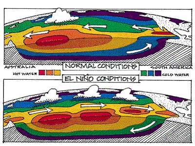
El Nino Southern Oscillation
Droughts and bushfires in Australia, floods and storms in the South-western US and Pacific coast, devastating losses in fisheries in South America. How could these events be possibly connected? Peruvian fishermen had long known that around every 5 - 8 years the fish that they normally had in abundance disappeared, along with many of the sea birds from the region which died from lack of food. This occurred around Christmas time so they named the event El Nino that is Spanish for "the Child".
Scientists showed that while this was occurring there were some major changes in the amount of warm water in both the central and eastern Pacific near South America. This pool of warm water replaced the normally cold-water nutrient rich upwellings that provided the start for the rich food chain that led to the fish that the Peruvian fishers depended on. In the western Pacific warm air moves east over the ocean, taking moisture filled air with it. At the same time as their are floods in South America, Australians experience severe drought.
One of the worst major El Nino events in Australia was the summer of the Ash Wednesday bushfires in 1983. In this year a long period of drought and high temperatures caused major bushfires throughout southern and eastern Australia with the loss of many lives. In 1997 another El Nino year saw devastating fires and drought over much of Australia and SouthEast Asia.
The need to be able to predict these devastating changes in our climate has resulted in a major international research program making use of satellites and ocean buoys with temperature sensors to measure changes and make models to warn people to prepare for hard times.
Scientists now believe that these events are caused by a shift in the ocean temperature pushing down the cooler water of the eastern Pacific and altering the climate above the Pacific Ocean. This shift is known as the Southern Oscillation hence the name of the event is known as the El Nino Southern Oscillation or ENSO.
The effects of the El Nino event were widespread in the Pacific basin countries in the summer of 1997 and 1998. In Late 1997 massive bushfires raged in South East Asia and Australia producing a thick blanket of smoke. At the same time torrential rains fell in areas that rarely receive rain such a Peru, California, and some Pacific islands causing massive floods and mudslides. |