From the "NSW Marine Habitat Mapping Project"
An estuary is a semi-enclosed coastal water body having a permanently or intermittently open connection with the ocean. Water levels inside an estuary vary in a periodic way in response to fluctuations in tides, weather patterns and freshwater inflow. The upstream boundary of an estuary is the limit of tidal influence and occurs in the lower reaches of the creeks and rivers draining into an estuary.
The 184 recognised estuaries in NSW fall into 5 main categories: semi-enclosed bays (6), drowned river valleys (13), barrier estuaries (51), intermittent estuaries (110) and brackish lakes (4). Variation in estuary type, entrance condition, catchment characteristics and climate produce ecosystems that are complex and dynamic. The seabed in estuaries is predominantly sandy or muddy, but rocky reefs and the hard surfaces of jetties, oyster racks and seawalls can provide considerable habitat complexity.
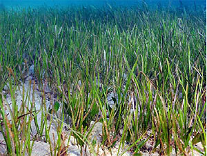
The soft sediments in the shallow parts of estuaries often support seagrasses, mangroves or saltmarsh plants. Together, these macrophytes provide habitat for a rich diversity of marine life. Unfortunately, some estuaries in NSW have been invaded by the introduced green seaweed Caulerpa taxifolia. This can form dense beds on the seafloor which can also be mapped.
Mapping the spatial arrangement of the different habitats helps scientists and coastal managers to better understand the ecosystem dynamics and the relationships between the seabed and the plants and animals living in estuaries. A variety of photographic and acoustic technologies are available to map seabed features in estuaries. These are variations of those used to map terrestrial vegetation on one hand and the deep ocean seafloor on the other. Interpretation of remote imagery, coupled with the ability to easily “ground truth” information within estuaries, allows researchers to produce highly accurate maps of bathymetry, topography and habitat.
Aerial Imagery
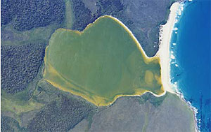
Aerial photographs captured from aircraft are traditionally the main data sources for mapping estuarine habitats. The best images are obtained when there is a clear view through the water to the seabed which occurs on cloudless days with calm seas, light winds, low sun angle and low tide. In the past, aerial photographs had to be digitally scanned and ortho-rectified (corrected for parallax error). More recent imagery comes in digital format, often with rectification already done. The outline around each habitat of interest is then traced manually on a computer screen by a skilled operator and stored in a Geographic Information System (GIS).
Images are now also available from satellites such as Quickbird or Modis. This imagery is spectral rather than strictly photographic but is analysed in much the same way as aerial photographs. Although software is available which can automatically delineate pre-programmed habitat features based on their “spectral signatures”, this is not always accurate and most estuarine mapping in NSW still relies on manual interpretation of the images.
Another approach being used in NSW is to get closer to the seabed habitats rather than use distant satellites. A specially designed “helipod” containing a high resolution digital camera is attached underneath a helicopter which is flown over the area of interest. This gives much greater control over the weather and tidal conditions at the time of flying and generally produces shaper images which are much easier to interpret.
Echosounders & Sidescan Sonar
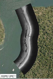
Where it is too deep to see seabed features in an aerial image, the reflection of sound off the seabed rather than light is used to map marine habitats. These acoustic mapping systems measure depth and record information about the physical structure of the seabed at all depths. An echosounder emits a sound pulse or ping and a measure of the seabed hardness and roughness can be estimated from the strength of the return signals or echoes reflected off the seabed. A sidescan sonar is a sophisticated echosounder that emits fan-shaped sound pulses from a transducer attached to a boat. It covers a much wider swath of the seabed than a basic echosounder.
Underwater Video
Maps produced from remote imagery, whether spectral or acoustic, are usually considered “preliminary”. They need to be checked. This is done by looking over the side of a boat (if the water is clear), sending down SCUBA divers to make direct observations, or by using underwater camera systems, particularly video. A video system can be part of the instrumentation on one of the many Remotely Operated Vehicles (or ROVs) that are now routinely used in marine research.
These are most effective in deep water, however, and simpler systems are usually used in shallow estuaries. Video footage is obtained either by a diver in the water or from a camera suspended below a boat. Such a video camera can simply be lowered on to a habitat of interest or towed along transects traversing different habitats. The video system used in NSW estuaries also automatically integrates positional information from a GPS and depth from an echosounder.
The video cameras transmit a live feed back to a screen on the vessel where researchers can observe the seabed and make on-the-spot changes to habitat boundaries. The footage is usually also recorded to a DVD for later detailed analysis. As well as validating the ‘preliminary’ habitat maps, video footage is used, in conjunction with other techniques such as still photographs or collected samples, to document the marine life associated with different habitats.
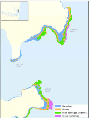
An example of a final map of the macrophytes in a NSW estuary can be found at www.dpi.nsw.gov.au/research/areas/systems-research/aquatic-ecosystems/estuarine-habitats-maps/
|