From the "NSW Marine Habitat Mapping Project"
Marine habitat mapping refers to the process of
using data derived mostly from remote-sensing
imagery to produce maps of seabed habitats. The
maps accurately identify the spatial location, extent
and characteristics of differing seabed habitats.
The overall process involves habitat
characterisation, habitat classification and habitat
mapping.
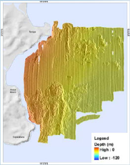
Habitat characterisation is carried out by means of
both acoustic (side-scan sonars, multi-beam swath
systems), and airborne mapping tools (satellite and
aerial photography). Such methods generally define
the broad habitat type (e.g. reef, sand, seagrass),
and further fine scale characterisation is conducted
using video or SCUBA sampling methods. Habitat
classification reduces the seabed characterisations
to a set of habitat classification types. This
information is then used to generate a classified
map of the various habitats in the survey area.
Why is Marine Habitat Mapping Important?
There are huge gaps in our knowledge about NSW
marine habitats and the biodiversity they support.
Marine habitat mapping is crucial to improve our
understanding of ecosystems, and relationships
with biota and habitats.
It will also assist natural resource managers to
sustainably manage and conserve marine resources
and identify habitats that may be under pressure
from humans or affected by such things as climate
change.
Information that has been collected by different
organisations over many years is currently being
collated and analysed, and additional mapping and
biodiversity assessments are being completed.
Mapping data will be available on the Ozcoasts
website: www.ozcoasts.org.au from late 2009.
Where will Marine Habitat Mapping take
place?
Mapping of mangroves, seagrass and saltmarsh will
be completed for all NSW estuaries to give a
complete set of data for estuarine macrophytes for
NSW. Mapping and biodiversity assessments of
rocky reefs and foreshore habitats will also be
completed in selected estuaries.
Seabed habitats outside of the estuaries, including
rocky reefs and soft-sediment areas will be mapped
at selected locations along the NSW coast, and
available broadscale bathymetry and sediment
information will be collated statewide. These
locations include areas within each coastal
Catchment Management Authority region including
offshore of Coffs Harbour, Forster, Terrigal and
Eden.
Which Methods will be used to Map Marine
Habitats?
Acoustic side-scan sonar methods and aerial
photography are being used to map marine habitats.
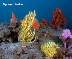
Digital video and still camera imagery are used to
conduct habitat surveys to increase knowledge of the
distribution of dominant sponge, algal and seagrass
habitats. 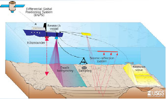
|